You’ll need a winning lottery ticket—or careful planning—to paddle down Utah’s upper San Juan River
I’d almost missed this display, which my guidebook estimated to be about a thousand years old, give or take a century, its author noting that the handprints’ significance is unknown. As I took in the mysterious art, the only sounds were birdsong and river burbles, and soon, I gave in to the unrelenting downstream push of the water. I had to catch up with my friends Theresa and James and their 5-year-old daughter, Fiadh, on the sapphire-blue, 16-foot raft just downriver, not to mention the supplies we’d packed for our three-night voyage.
A couple months earlier, Theresa and James had secured a coveted permit to float this mostly placid, 27-mile stretch of the San Juan between the small Utah towns of Bluff and Mexican Hat in June. While using such visitor permits to limit crowds in national parks is a relatively new and sometimes controversial phenomenon, popular American rivers have long employed them to protect wildlife and the fragile riparian environments.

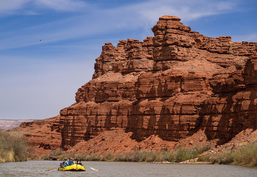
The author’s friend Theresa Graven paddles the last stretch of the upper San Juan River under the Mexican Hat rock formation. Photo: Brigid Mander
Each year, thousands apply for permits, via the Bureau of Land Management’s tightly controlled access lottery, to float this section of the river during April to July, the most popular months. Permits for the fall months are easier to nab, since the water is lower then and the nights chillier, though the scenery is even more spectacular. With only a few dozen people allowed in daily any time of year, you’ll rarely see anyone beyond your own party as you’re paddling along the San Juan.

Before we set off, Theresa mentioned another perk: “We can see petroglyphs, pictographs, rock carvings and cliff dwellings,” she said. “It’s like Mesa Verde, but with no crowds.” The agricultural, maize-cultivating people of the Ancestral Puebloan cultures had thrived in the region until around 1200, leaving abundant evidence of their lives on the landscape.
The headwaters of the San Juan, one of the Colorado River’s largest tributaries, begin high in Colorado’s San Juan Mountains, then merge with the Animas River, dip into New Mexico and wind north again to Bluff, Utah, where our river trip would begin. The majority of the two-hour drive from my friends’ home in Durango, Colo., to Bluff crossed a landscape straight out of Frank Herbert’s “Dune” novels, which are set on a fictional desert planet, Arrakis. It was a world of dry dirt, sand and rocks. Fierce gusts blew up dust, dulling the blue sky above. The only life we saw were a few skinny cows and a forlorn calf crossing a barren pasture, looking truly lost.
The searing landscape shocked us, but perhaps it shouldn’t have. The Western U.S. has been in an intense drought since the early 2000s. The Colorado River is running at an all-time low; the reservoirs created by 20th-century dams to facilitate large-scale agriculture and development have dropped significantly.
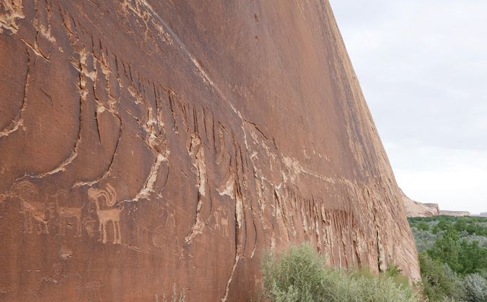
One of the petroglyph panels along the upper San Juan River.Photo: Brigid Mander
Archeologists believe a severe drought period many centuries ago forced the rapid depopulation of the cities and farms in the area, the remnants of which we were so keen to see along the river banks. For now, the Navajo Dam, upstream in New Mexico, keeps enough water flowing downstream for native fish populations—and, by default, paddlers.
When we arrived in Bluff, stands of green cottonwoods jubilantly announced the otherwise hidden thread of water, winding along out of sight below the dusty plateau. Rafting does not mean roughing it, James was eager to point out. OARS, among the other tour operators that run guided trips along the San Juan, entices clients with cushy camping gear, good meals and wine. James did his best to approximate those upscale expeditions with some luxuries of our own: coolers filled with gourmet delectables and a grill. We tied a paddleboard to the side of the raft and pushed off.
Our raft glided along next to sheer red cliffs and sandy shores. One river bank offered a wild vista of the Navajo Nation’s lands; the other was U.S. federal land, also seemingly untouched. Cottonwoods and lush willows contrasted starkly with the red and yellow rocks. Three burros quenching their thirst watched us glide past. Cliff swallow nests clung improbably to overhanging cliffs and we could hear the tiny chirps of their occupants.
That first evening, we pulled ashore at one of the designated camps on a sandy beach and unloaded our supplies. Little Fiadh stretched out on a blanket eating cherries, cheese and prosciutto, resembling Cleopatra on the Nile. We pitched our tents on the sand, then made a fresh salad and fajitas for dinner. We awoke to the gentle riffles of the river.

The author’s campsite in one of the designated riverside camping areas along the San Juan. Photo: Brigid Mander
With the help of the detailed book “San Juan River Guide,” by Lisa Kearsly, we were able to find several historic sites along the river, including Butler Wash Panel, a vast, mesmerizing display of stylized humans, symbols and animals carved high into a cliff.
Another day we drifted toward River House, a mostly intact cliff-dwelling (believed to have been used 800 to 1,000 years ago), a 10-minute walk up a trail from the river. Dried ears of corn and pottery shards were still visible on the earthen floor. Predictably, we were alone there, too. Back on the raft, whenever the sun felt too harsh, we’d jump into the river, the initial chill dissipating quickly. James took Fiadh on the paddleboard to ride the child-size rapids.
Eventually, the willows and red cliffs receded and the river narrowed into a winding channel, cut steeply into the plateau, known as Goosenecks. We passed a large group of bighorn sheep rams in a swath of thickly vegetated riverbank. We understood why we were treated to such abundant wildlife sightings: All the creatures, including us, had converged around this fragile thread of water in a vast, arid land.
On our last morning, we sat on the riverbank enjoying a leisurely coffee in the sun. Our next stop was the takeout, where we’d exit the river, at Mexican Hat, named for a rock formation that looked like a wide-brimmed hat balanced on a round head. Pretty soon we were back on the planet Arrakis and already planning our next float trip, with or without a winning lottery ticket.
The Lowdown // How to Book a Float Trip Along Utah’s San Juan River

Rochester Hotel in Durango, Colo. The old mining town, now an outdoor sports hub with a regional airport, offers visitors plenty of creature comforts pre- or post-rafting trips. Photo: Elizabeth Wells
Getting There
Durango, Colo.—about two hours by car from Bluff, Utah—is home to the main regional airport in southwest Colorado, serviced by both American and United Airlines.
Staying There
Before or after your float trip, consider spending the night in affable Durango. Bunk down at Rochester, a small high-end hotel that highlights the town’s past as a booming mining town. From $350 a night, RochesterHotel.com
Floating There
For float trips between April 15 and July 15, 2023, the first day to enter the permit lottery (offered by the Bureau of Land Management) is Dec. 1, 2022; the last day is Jan. 31, 2023. If you don’t have your own raft and would rather explore the San Juan with an experienced guide, OARS offers family-friendly, multi-day guided trips. From $1,149 per person for three nights, oars.com. Another good choice is Tse Kooh Outfitters, a small guiding operation that focuses on the archeological and cultural sites along the San Juan. From $850 per person for two nights, TseKoohOutfitters.com
Blog Post By: https://www.wsj.com/articles/rafting-trip-utah-for-only-the-lucky-few-11665587576?st=6sfr6rr62gclqck&
